stactools package for Landsat data

Project description
stactools-landsat


- Name: landsat
- Package:
stactools.landsat - PyPI: http://mirror-pypi-de.runflare.com/project/stactools-landsat/
- Owners:
- @lossyrob
- @pjhartzell
- @gadomski
- Dataset homepages:
- STAC extensions used:
This repository will assist you in the generation of STAC files for Landsat datasets. The table below provides an overview on Landsat Mission's sensors and band wavelengths.
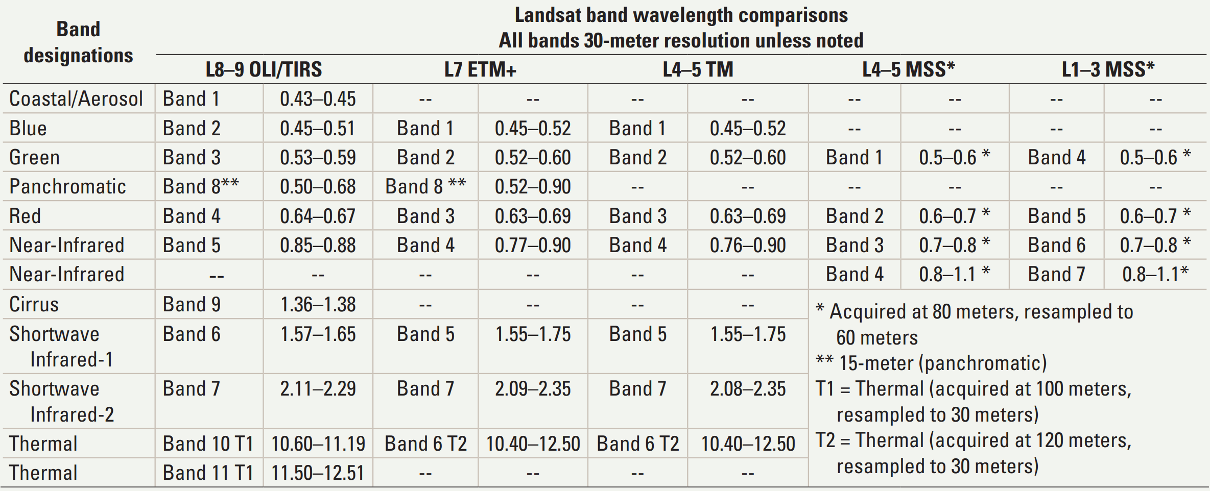
Source: https://pubs.usgs.gov/fs/2015/3081/fs20153081.pdf
Examples
STAC Collections and Items
Command-line usage
To create a STAC Item:
$ stac landsat create-item --mtl tests/data-files/oli-tirs/LC08_L2SP_047027_20201204_20210313_02_T1_MTL.xml --output examples --usgs_geometry
To create a STAC Collection from a text file containing a list of Landsat scene XML metadata files:
$ stac landsat create-collection --file_list examples/c2-l2-file-list.txt --output examples/landsat-c2-l2 --id landsat-c2-l2 --usgs_geometry
The above create-collection command is exactly how the contents of the examples/landsat-c2-l2 directory are generated.
Release history Release notifications | RSS feed


Download files
Download the file for your platform. If you're not sure which to choose, learn more about installing packages.
Source Distribution
stactools-landsat-0.2.4.tar.gz
(30.1 kB
view hashes)
Built Distribution
Close
Hashes for stactools_landsat-0.2.4-py3-none-any.whl
| Algorithm | Hash digest | |
|---|---|---|
| SHA256 | 2f4852a43d9259ee1554917f4f327b52f897af5ed838163ce5236e65702ddf80 |
|
| MD5 | 5eec5f0e3f8581c3a0923d7abed8e879 |
|
| BLAKE2b-256 | 68d49efaee8c1eae2e103f769961fa002ae3caaef48cb28d1d6502e72fe33800 |


